


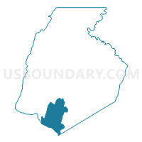
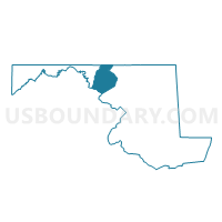
Frederick Precinct 01-001, Frederick County, Maryland
About
Outline

Summary
| Unique Area Identifier | 592333 |
| Name | Frederick Precinct 01-001 |
| County | Frederick County |
| State | Maryland |
| Area (square miles) | 38.11 |
| Land Area (square miles) | 36.76 |
| Water Area (square miles) | 1.35 |
| % of Land Area | 96.46 |
| % of Water Area | 3.54 |
| Latitude of the Internal Point | 39.29600420 |
| Longtitude of the Internal Point | -77.47177800 |
Maps

Graphs
Select a template below for downloading or customizing gragh for Frederick Precinct 01-001, Frederick County, Maryland


Neighbors
Neighoring Voting District (by Name) Neighboring Voting District on the Map
- Frederick Precinct 01-002, Frederick County, MD
- Frederick Precinct 07-001, Frederick County, MD
- Frederick Precinct 14-001, Frederick County, MD
- Frederick Precinct 23-001, Frederick County, MD
- Lucketts Voting District, Loudoun County, VA
- Montgomery Precinct 03-001, Montgomery County, MD
- Waterford Voting District, Loudoun County, VA
Top 10 Neighboring County Subdivision (by Population) Neighboring County Subdivision on the Map
- Catoctin district, Loudoun County, VA (45,461)
- District 7, Urbana, Frederick County, MD (15,071)
- District 1, Buckeystown, Frederick County, MD (10,218)
- District 3, Montgomery County, MD (6,295)
- District 23, Ballenger, Frederick County, MD (5,544)
- District 14, Jefferson, Frederick County, MD (4,795)
Top 10 Neighboring Place (by Population) Neighboring Place on the Map
- Ballenger Creek CDP, MD (18,274)
- Adamstown CDP, MD (2,372)
- Point of Rocks CDP, MD (1,466)
- Buckeystown CDP, MD (1,019)
Top 10 Neighboring Unified School District (by Population) Neighboring Unified School District on the Map
- Montgomery County Public Schools, MD (971,777)
- Loudoun County Public Schools, VA (312,311)
- Frederick County Public Schools, MD (233,385)
Top 10 Neighboring State Legislative District Lower Chamber (by Population) Neighboring State Legislative District Lower Chamber on the Map
- State Legislative District 15, MD (137,447)
- State House District 33, VA (113,100)
- State Legislative Subdistrict 3B, MD (54,040)
Top 10 Neighboring State Legislative District Upper Chamber (by Population) Neighboring State Legislative District Upper Chamber on the Map
- State Senate District 27, VA (227,068)
- State Senate District 3, MD (147,548)
- State Senate District 15, MD (137,447)
Top 10 Neighboring 111th Congressional District (by Population) Neighboring 111th Congressional District on the Map
- Congressional District 10, VA (869,437)
- Congressional District 6, MD (738,943)
- Congressional District 8, MD (728,124)
Top 10 Neighboring Census Tract (by Population) Neighboring Census Tract on the Map
- Census Tract 6103, Loudoun County, VA (6,642)
- Census Tract 7005, Montgomery County, MD (6,295)
- Census Tract 7523.01, Frederick County, MD (4,168)
- Census Tract 7523.02, Frederick County, MD (3,983)
- Census Tract 7523.03, Frederick County, MD (2,640)
- Census Tract 7525.02, Frederick County, MD (2,487)
- Census Tract 7522.01, Frederick County, MD (2,121)
Top 10 Neighboring 5-Digit ZIP Code Tabulation Area (by Population) Neighboring 5-Digit ZIP Code Tabulation Area on the Map
- 20176, VA (46,506)
- 21703, MD (32,854)
- 21704, MD (13,321)
- 20180, VA (6,549)
- 21755, MD (5,591)
- 21710, MD (4,515)
- 20842, MD (1,824)
- 21777, MD (1,470)
- 21790, MD (100)
- 21717, MD (54)